
San Clemente Beaches & Surfing: Pier, T-Street, North Beach & More
For buyers considering living in San Clemente, California, the coastline is much more than a scenic backdrop. San Clemente beaches and surfing are woven into the city’s neighborhoods, recreation, local identity, and everyday lifestyle.
From North Beach and the San Clemente Pier to T-Street, Linda Lane, Calafia, San Clemente State Beach, and the legendary surf breaks around Trestles and San Onofre, this stretch of South Orange County offers multiple ways to experience the Pacific.
But not every San Clemente beach feels the same.
Some provide easier parking and amenities. Others require stairs down coastal bluffs. Some are closely tied to surfing. Others work better for walking, relaxing, family beach days, or accessing the San Clemente Beach Trail.
And for home buyers, proximity to one beach can create a very different lifestyle from proximity to another.
Here is what buyers should know about San Clemente beaches and surfing before deciding where to live.
San Clemente Beaches and Surfing at a Glance
The City of San Clemente identifies a series of public beach access points running along the coastline, including:
- North Beach
- Dije Court
- El Portal
- Mariposa
- Linda Lane
- Corto Lane
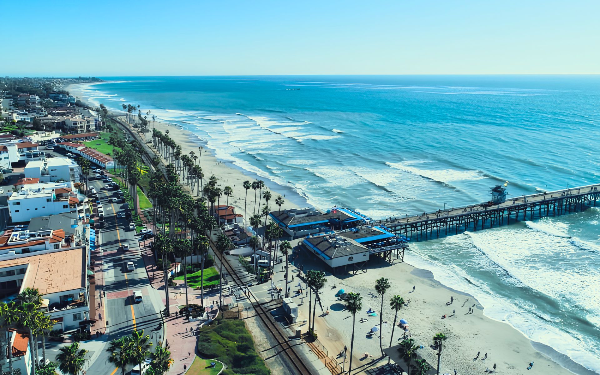
- San Clemente Pier
- T-Street
- Lasuen, also known as Lost Winds
- Riviera
- Calafia
Amenities vary significantly. North Beach and the Pier have ADA access, metered parking, restrooms, and nearby train stations, while smaller access points such as Dije Court, El Portal, Mariposa, Lasuen, and Riviera are reached primarily by stairs.
That variety is part of what makes San Clemente different from a beach city built around one primary stretch of sand.
North Beach: Coastal Access at the Northern End of San Clemente
North Beach is one of the most recognizable access points on the northern side of the San Clemente coastline.
The City lists amenities including:
- ADA beach access
- Fire ring
- Metered parking
- Restrooms
- Train station
It also serves as the northern end of the San Clemente Beach Trail.
For home buyers, North Beach can be especially interesting because beach recreation, walking, rail access, and nearby neighborhoods come together in one area.
The setting feels different from the Pier Bowl.
You are still close to the water and coastal trail, but farther from the concentration of activity surrounding Avenida Del Mar and the Pier.
That may appeal to someone who wants regular coastal access without necessarily wanting to live directly beside San Clemente’s busiest central beach destination.
San Clemente Pier: The City’s Coastal Landmark
The San Clemente Pier is probably the city’s most recognizable coastal landmark.
The City lists the Pier beach area with:
- ADA access
- BBQ facilities
- Concessions
- Fire ring
- Metered parking
- Restrooms
- Train station
For residents, the Pier is about more than going to the beach.
It sits at the intersection of the coastline, the Pier Bowl, Avenida Del Mar, restaurants, the Beach Trail, rail service, and nearby residential streets.
That gives the surrounding area one of San Clemente’s most distinctive combinations of walkability and coastal access.
Someone living close to the Pier may be able to make the beach part of an ordinary morning or evening routine.
Someone living farther inland may still use the Pier regularly, but the experience becomes more of a destination.
Can You Surf at the San Clemente Pier?
Yes, but buyers and visitors should understand that surfing is regulated around the Pier.
The City’s coastal planning materials identify the north side of the Pier as an established surf break. Surfing on the south side of the Municipal Pier is prohibited.
That makes the Pier part of San Clemente’s surf culture without turning the entire beach into one unrestricted surf zone.
For someone considering a property near the Pier specifically because they surf, it is worth learning the local rules rather than assuming all nearby water is managed the same way.
T-Street Is One of San Clemente’s Best-Known Local Beaches
T-Street, located at 339 W. Paseo De Cristobal, is one of the city’s signature beach and surf areas.
The City currently lists:
- Stair access
- Concessions
- Fire ring
- Metered parking
- Restrooms
The beach operates from 4 a.m. to 10 p.m. under the current City facility listing.
T-Street also has strong local surfing significance.
The City identifies it as one of San Clemente’s established surfing areas, along with the Pier, 204, Lost Winds, Riviera, State Park, and Cotton’s Point.
That makes T-Street especially relevant for buyers whose idea of San Clemente living includes regularly getting into the water rather than simply enjoying an ocean view.
T-Street Has Seasonal Surfing Restrictions
Surf access at T-Street is not completely unrestricted throughout the summer.
The City’s current T-Street facility page says board surfing is prohibited from June 14 through August 18 between 11 a.m. and 6 p.m. daily.
This is an important local detail.
Someone buying near T-Street because they imagine surfing outside the house at any hour should understand that beach management changes seasonally for swimmer safety.
Early mornings and evenings may become more important for surfers during those periods.
Beach rules can change, so residents should always check current City signage and Marine Safety information.
Linda Lane Offers Another Central Beach Option
Linda Lane sits north of the Pier and provides another useful central San Clemente beach access point.
The City lists:
- ADA access
- Metered parking
- Restrooms
Linda Lane is especially relevant because it sits directly along the Beach Trail between North Beach and the Pier.
For buyers, it can offer a middle ground.
You can be close to the central coastal lifestyle without necessarily being directly beside the Pier Bowl.
This can make Linda Lane and nearby residential streets worth comparing with both North Beach and downtown-adjacent areas.
Smaller Beach Access Points Create Different Neighborhood Experiences
San Clemente’s coastline includes a number of smaller access points that do not have the same visibility as the Pier or T-Street.
These include:
Dije Court
Stair access.
El Portal
Stair access.
Mariposa
Stair access.
Corto Lane
Stair access, restrooms, and a volleyball court.
Lasuen / Lost Winds
Stair access and volleyball.
Riviera
Stair access to the State Beach area.
These locations matter in real estate because they can dramatically change the meaning of “close to the beach.”
A home may not be near the Pier but could still sit near a neighborhood access point that makes reaching the sand relatively convenient.
For buyers who value beach access more than commercial activity, one of these smaller access points may actually be preferable.
Lost Winds and Riviera Are Part of San Clemente’s Surf Map
San Clemente’s official coastal planning materials identify both Lost Winds and Riviera as established surf areas.
Lost Winds is described as a beach break near the Lasuen access point, while Riviera is associated with the Riviera Beach access area farther south.
These beaches generally receive less attention from people researching San Clemente online than the Pier or T-Street.
But for buyers, they are another example of why San Clemente should be evaluated at a very local level.
Living near one access point may give you a completely different daily beach routine from living a few neighborhoods away.
Calafia Marks the Southern End of the City Beach Trail
Calafia is another important beach access point at the southern end of the San Clemente Beach Trail.
The City lists stair access, concessions, and restrooms at Calafia.
California State Parks identifies Calafia State Beach as directly adjacent to San Clemente State Beach, with both using Avenida Calafia for access.
Calafia also serves as the southern trailhead of the City’s 2.3-mile Beach Trail.
For buyers interested in the southern side of San Clemente, this area combines beach access with the bluff and State Beach environment rather than the downtown feel of the Pier.
San Clemente State Beach Offers a Different Coastal Experience
San Clemente State Beach sits at the southern end of the city.
California State Parks describes it as a mile-long beach positioned between the surf and a steep bluff, with views of the ocean, hills, and mountains.
Activities include:
- Swimming
- Surfing
- Paddle boarding
- Body surfing
- Snorkeling
- Sunbathing
That environment feels noticeably different from the more urbanized Pier area.
For buyers who value coastal scenery and recreation but prefer being farther from downtown activity, homes in the southern portions of San Clemente may deserve a closer look.
The San Clemente Beach Trail Connects the Coast
One of the most valuable features tying San Clemente beaches together is the San Clemente Beach Trail.
The City describes the trail as 2.3 miles long, running from North Beach to Calafia Beach, with stops at the Pier and T-Street.
The trail is used by:
- Walkers
- Joggers
- Traditional bicycles
- Dog walkers
The City requires dogs to remain on a leash of six feet or shorter and states that dogs are not permitted on the beach. E-bikes and similar motorized devices are also prohibited on the Beach Trail.
For residents, this trail can turn several separate beach access points into one connected coastal recreation system.
The Beach Trail Was Fully Reconnected in October 2026
This is an important current update.
On October 9, 2026, OCTA officially reopened the San Clemente Beach Trail at Mariposa Point after completing a major coastal rail protection project.
The project included a nearly 1,400-foot catchment wall, a new pedestrian bridge at Mariposa Channel, trail reconstruction, landscaping, and other improvements. The reopening restored the connection through a section that had been disrupted after a January 2024 landslide destroyed the previous trail bridge.
For residents and buyers, that means the continuous coastal trail connection between North Beach and the southern beach areas is once again a meaningful part of everyday coastal recreation.
The Beach Trail and Railroad Share the Coastline
One thing buyers unfamiliar with San Clemente may not realize is how closely the rail corridor, Beach Trail, cliffs, and coastline interact.
The City specifically reminds Beach Trail users to remain on designated paths and railroad crossings because the rail right-of-way belongs to OCTA.
This is part of San Clemente’s distinctive coastal geography.
In some areas, the beach, train tracks, trail, bluffs, and homes are all relatively close together.
That can create spectacular views and access, but it also creates property-specific considerations that will be explored later in the San Clemente coastal homes guide.
San Onofre Is Just South of San Clemente
No discussion of San Clemente beaches and surfing is complete without nearby San Onofre State Beach.
California State Parks places San Onofre approximately three miles south of San Clemente along I-5 at Basilone Road.
The park has three major areas:
- San Onofre Bluffs
- San Mateo Campground
- San Onofre Surf Beach
It attracts surfers, swimmers, campers, cyclists, anglers, kayakers, birders, and other coastal recreation users.
Although it sits just outside San Clemente’s city limits, it is closely tied to the city’s coastal lifestyle.
San Onofre Offers Different Types of Surfing
San Onofre is not one single surf break.
California State Parks identifies several distinct areas.
Surf Beach
Surf Beach includes:
- The Point
- Old Man’s
- Dogpatch
State Parks notes that the area generally slows incoming surf, giving it a different character from the higher-performance waves at Trestles.
Church
Church is another named surf area near the Camp Pendleton Beach Resort.
Trails
Trails sits farther south and includes both rock-bottom and sandy breaks.
Trestles
Trestles is the internationally recognized end of the spectrum.
State Parks describes it as a premiere U.S. surf destination known for consistent waves.
This range is one reason the San Clemente/San Onofre area has such a strong surf identity.
Trestles Is One of Southern California’s Most Recognized Surf Destinations
Trestles sits just south of the San Clemente city boundary and is part of San Onofre State Beach.
Unlike a typical beach parking situation, California State Parks notes that Trestles cannot be reached directly by vehicle. Surfers and visitors access it by walking along a nature trail from the north or south and passing beneath the Trestles Bridge.
For a surfer considering San Clemente real estate, this matters.
Living closer to the southern end of the city may make trips toward Trestles feel more convenient, while someone near North Beach will have a different local surf routine.
Again, the specific neighborhood matters.
San Clemente Has Multiple Established Surf Areas
San Clemente’s official coastal planning materials identify eight established surfing areas within the City’s boundaries, including:
- 204
- The Pier
- T-Street
- Lost Winds
- Riviera
- State Park
- Cotton’s Point
- The northern Poche-area coastline
The City also specifically notes the importance of nearby Trestles and San Onofre, just outside the city limits.
For buyers who surf, this is a significant advantage.
Instead of having one primary surf beach, residents can have several coastal options depending on conditions, skill level, location, and beach regulations.
Which San Clemente Beach Fits Your Lifestyle?
There is no single “best San Clemente beach.”
The better question is:
Which beach best fits how you plan to use the coast?
Consider North Beach if:
- You want easier beach access
- You value the Beach Trail
- You want nearby rail access
- You prefer the north end of San Clemente
Consider the Pier area if:
- You want the classic San Clemente coastal setting
- You value proximity to Avenida Del Mar
- Restaurants and downtown matter
- You want beach and rail access in the same area
Consider T-Street if:
- Surfing is important
- You want a recognizable local beach
- You are comfortable with stairs and seasonal surfing restrictions
Consider Linda Lane if:
- You want central beach access
- You value the Beach Trail
- You prefer being between North Beach and the Pier
Consider Calafia and State Beach if:
- You like the bluff-and-beach environment
- You prefer southern San Clemente
- State Beach recreation matters
- You want easier access toward San Onofre and Trestles
These are lifestyle distinctions rather than rigid neighborhood recommendations.
The exact home still matters more than the beach name.
Beach Proximity Can Mean Different Things in San Clemente
When a listing says a home is “close to the beach,” ask what that actually means.
Does the property have:
- A walkable beach route?
- Stair access?
- A bluff between the home and the water?
- A railroad crossing?
- A steep uphill return walk?
- Nearby public parking?
- Direct Beach Trail access?
- Easy driving access instead of walking access?
San Clemente’s hills and coastal bluffs can make a short distance on a map feel very different in real life.
Walk the route yourself before buying.
Ocean View Does Not Automatically Mean Easy Beach Access
This is another important San Clemente distinction.
A hillside home may have an impressive ocean view while requiring a drive to reach the beach.
A smaller home closer to the Pier or Linda Lane may have less dramatic views but much easier access to the sand.
Those are different lifestyle benefits.
Buyers should decide whether they value:
seeing the ocean
or
using the ocean
or both.
The answer can influence which part of San Clemente makes the most sense.
Beach Parking Matters More Than Buyers May Expect
Parking varies significantly along the coast.
The City lists metered parking at North Beach, Linda Lane, the Pier, and T-Street, while several smaller beach access points depend more heavily on neighborhood or street access.
Someone living within walking distance of the beach may use their car much less for coastal recreation.
Someone living inland may care more about where they can reliably park.
This becomes even more noticeable during summer, weekends, holidays, surf events, and good-wave days.
The future San Clemente parking, beach crowds, and summer traffic guide will cover this in much greater detail.
Rail Access Is Unusually Close to the Beach
San Clemente also has the unusual combination of beach access and passenger rail.
The City lists train stations at both North Beach and the Pier beach area.
Metrolink currently lists the San Clemente Pier Station at 615 Avenida Victoria, with Orange County and Inland Empire–Orange County Line service depending on the schedule.
That creates a coastal transportation option that many other South Orange County communities simply do not have.
We will cover train schedules and commuting more deeply in the San Clemente transportation guide.
What Buyers Should Check When Beach Access Matters
If the coast is one of your main reasons for buying in San Clemente, test the lifestyle before choosing a property.
Walk to the Beach
Do not rely only on map distance.
Walk Back Home
The return route may involve significantly more elevation.
Visit on a Weekend
A quiet Wednesday morning does not show you summer or weekend conditions.
Check the Nearest Access Point
The closest beach entrance may not be the Pier.
Look at the Parking Situation
Consider both your own household and visiting guests.
Visit at High and Low Tide
The usable beach environment can look very different.
Check Current Beach Rules
Surfing, swimming, fires, parking, dogs, and other activities are regulated.
Walk the Beach Trail
If you expect to use it regularly, experience the section closest to the home.
Check Current Coastal Conditions
Beach access, rail work, surf conditions, and coastal infrastructure can change.
Current Coastal Conditions Can Change
San Clemente’s coastline is dynamic.
The recent Mariposa Point reconstruction is a clear example: the Beach Trail was severed after a 2024 landslide and fully reconnected in October 2026 after major stabilization work.
San Onofre has also experienced temporary access and facility restrictions in October 2026 after high surf and coastal erosion damaged portions of Surf Beach infrastructure.
That does not diminish the value of the coastal lifestyle.
It simply means buyers should understand that beach access and coastal infrastructure can evolve.
Who May Love San Clemente Beaches and Surfing?
San Clemente beaches and surfing may be especially appealing if you:
- Surf regularly
- Want the Pacific Ocean to be part of everyday life
- Enjoy beach walks
- Use coastal trails
- Want several beach access options
- Like having both city beaches and State Beaches nearby
- Want access to San Onofre and Trestles
- Prefer a community with a strong surf identity
- Value sunset walks, ocean views, and coastal recreation
- Like being able to choose between active beach areas and quieter access points
Who May Not Prioritize the Beach Lifestyle?
The coastal advantage may matter less if you:
- Rarely use the beach
- Prefer larger inland homes over coastal proximity
- Want less seasonal visitor activity
- Do not want to deal with beach parking
- Prefer newer master-planned amenities
- Are uncomfortable with coastal maintenance considerations
San Clemente may still work for you, especially in inland neighborhoods, but you may not place the same value on one of the city’s strongest lifestyle features.
San Clemente Beaches and Surfing FAQ
What are the main beaches in San Clemente?
The City identifies public access points including North Beach, Dije Court, El Portal, Mariposa, Linda Lane, Corto Lane, the Pier, T-Street, Lost Winds, Riviera, and Calafia.
What is the most famous beach in San Clemente?
The San Clemente Pier area is the city’s most recognizable central beach destination, while T-Street is especially well known locally for surfing. Nearby Trestles has international significance within surfing.
Can you surf at T-Street?
Yes. T-Street is an established San Clemente surfing area, although the City currently restricts board surfing between 11 a.m. and 6 p.m. from June 14 through August 18.
Can you surf at San Clemente Pier?
Surfing is allowed on the north side of the Pier surf area. The City’s coastal documents state that surfing south of the Municipal Pier is prohibited.
Where is North Beach?
North Beach is at the northern end of San Clemente’s main city beach system and Beach Trail. It offers ADA access, parking, restrooms, a fire ring, and rail access.
How long is the San Clemente Beach Trail?
The City lists the Beach Trail as 2.3 miles, connecting North Beach with Calafia Beach and passing the Pier and T-Street.
Is the San Clemente Beach Trail currently open?
The Mariposa Point section officially reopened on October 9, 2026, restoring an important connection after major coastal rail stabilization and trail reconstruction work. Conditions can still change, so users should check City and OCTA updates before visiting.
Where is San Clemente State Beach?
San Clemente State Beach is at the southern end of the city at 225 W. Calafia Avenue. Calafia State Beach is directly adjacent.
Is Trestles in San Clemente?
Trestles sits just south of San Clemente within San Onofre State Beach. State Parks notes that it is not directly accessible by vehicle and requires a walk to reach the surf area.
Is San Onofre close to San Clemente?
Yes. California State Parks places San Onofre State Beach approximately three miles south of San Clemente along I-5 at Basilone Road.
Are dogs allowed on San Clemente beaches?
The City’s Beach Trail rules state that dogs must remain on a leash of six feet or shorter on the trail and are not permitted on the beach.
Are e-bikes allowed on the San Clemente Beach Trail?
No. The City states that e-bikes and similar motorized devices are not permitted on the Beach Trail.
Thinking About Buying or Selling a Home in San Clemente?
The appeal of San Clemente beaches and surfing is not simply that the city sits beside the Pacific Ocean.
It is the variety of ways residents can experience the coast.
North Beach offers a different environment from the Pier.
T-Street is different from Linda Lane.
Calafia and San Clemente State Beach feel different from downtown.
And nearby San Onofre and Trestles add another layer to the local surf and outdoor lifestyle.
The right home depends on whether you value walkability to the sand, surf access, ocean views, parking, Beach Trail proximity, quieter coastal streets, or easier access to the southern surf areas.
Explore More About Living in San Clemente
If San Clemente beaches and surfing are one of the reasons you are considering the city, start with the complete San Clemente community guide:
5 Reasons You’ll Love Living in San Clemente and 3 Reasons It Might Not Be for You
Recent Updates
5 Reasons You’ll Love Living in San Clemente and 3 Reasons It Might Not Be for You
If you’re considering living in San Clemente, CA, you’re probably looking for more than homes for sale and ocean-view listing photos. You want to know what everyday life actually feels like. San Clemente sits at the southern end of Orange County, where residential neighborhoods climb coastal hills above the Pacific Ocean. The city combines beaches […]
Portola Hills Inland Location: Freeway & Beach Access Tradeoffs
For buyers considering eastern Lake Forest, the Portola Hills inland location can be either an advantage or a tradeoff depending on how often you expect to use Interstate 5, visit the coast, or travel throughout South Orange County. Portola Hills sits in the foothills of Lake Forest, California, near Whiting Ranch Wilderness Park, Portola Center, […]

Portola Hills Fire Risk & Home Insurance: What Buyers Should Research
For buyers considering the foothill side of Lake Forest, Portola Hills fire risk and home insurance deserve the same careful attention as the home itself, the HOA, the view, and the commute. Portola Hills sits near hills, open space, vegetation, and Whiting Ranch Wilderness Park. Those natural surroundings are a major part of the community’s […]
Join Our Mailing List
Are you interested in buying a home? Look no further than working with real estate experts.
Quick Links
Brokerage Info
25950 Acero., #100
Mission Viejo, CA 92691
DRE 01200533


All information is deemed reliable but not guaranteed and should be independently reviewed and verified.
Powered by Sprout Interactive

